Take a walk back in time
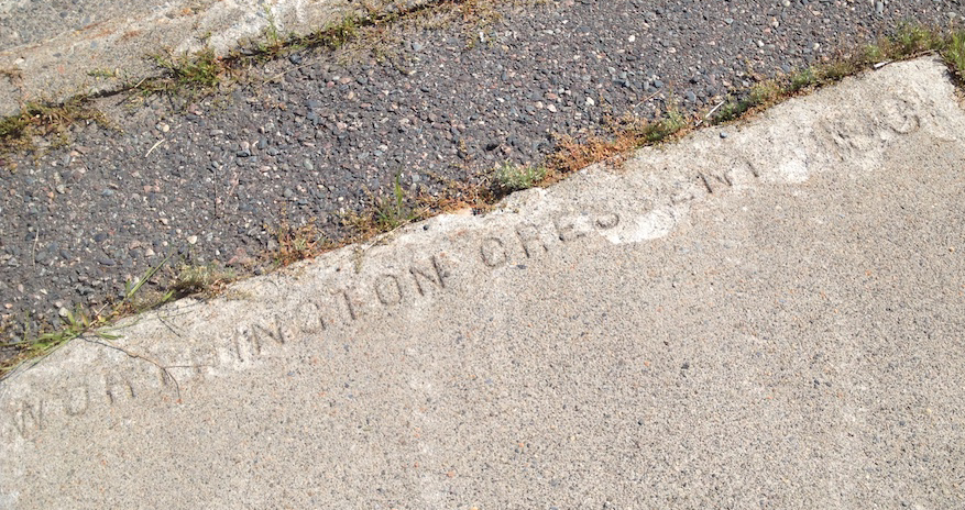
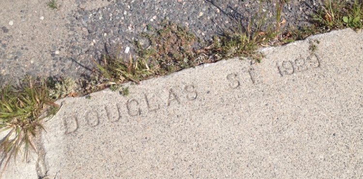
Perhaps you’ve stumbled upon these inconspicuous sidewalk markings in the Kingsmount neighbourhood. If not, the discovery awaits you. The 2 km loop on the attached map connects all eight stamps and can be started from any point.
A sidewalk primer
It is reported that when Patrick and Minnie Frawley arrived in March 1889, Sudbury had three sidewalks constructed of packing boxes in mud.
By 1895, the Town of Sudbury had established a Roads, Streets and Bridges Committee. The installation of raised Cedar plank sidewalks was approved on the condition that property owners along the stretch would pay a portion of the costs.
It wasn’t until 1905 that Town Council considered a by-law relating to the construction of Granolithic sidewalks. Granolithic concrete, a type of construction material composed of cement and fine aggregate such as granite, provided a permanent durable surface. The first streets targeted for concrete sidewalks were parts of Elm, Elgin and Durham. It would be another five years before the suburbs would get the granolithic treatment. Some of the first sidewalks poured in the suburbs were along parts of Marion, Paris and John. Sixty percent off the cost was to be paid by the owners of the property fronting these improvements. The contract was awarded to D.L. Brown (aka “The Cement King”). Brown’s Concrete, established in Sudbury in 1907, was the town’s first manufacturer of concrete products.
The origins of sidewalk stamping
Sidewalk stamping in North America dates back to the turn-of-the-20th-century. Berkley California has sidewalk stamps dating from 1899, Portland from 1902, Vancouver from 1906, and Calgary from 1909. There is no consensus on the oldest stamp in Toronto but there is one dated 1913 on Toronto Island. In Sudbury, the oldest sidewalk stamp appears to be 1929.
There are two types of stamps used in Sudbury. The first spells out the contractor name and the date. The second simply has the name of the street and the date when the sidewalk was poured. The latter appears to be unique to the Kingsmount area (I have heard of one in the West End). In recent years I have identified eight – six remain on public sidewalks, one has been repurposed into a private driveway and one has been lost due to a sidewalk upgrade.
Originally, these sidewalk stamps marked the year the sidewalk was laid, similar to dating buildings and bridges. Today, they inform the origin of a neighbourhood or a pattern of urban development.

1 Worthington Crescent 1931? (Southeast corner)
At the corner of Worthington and Riverside, the sidewalk stamp date is becoming more difficult to read. An educated guess would be 1931.
This was a very busy corner as Riverside Dr. was a level railway crossing. Every day, dozens of pedestrians and drivers would have waited at the intersection for a train to pass before proceeding to Station Street (Elgin Street). In 1943, a census of traffic over the Riverside crossing counted more than 10,000 motor vehicles and 15,000 pedestrians over a three day period – by far the busiest of all the north-south crossings in the city.

2 Front St. 1945 (Northeast corner)
The stamp at Front and O’Connor and two others in the neighbourhood are dated 1945. World War II ended and construction activity resumed.
The trio of stately homes on Front Street (61, 67 and 79) are some of the oldest homes south of the CPR tracks. Mayor Larry O’Connor (1905, 1906, 1907, 1910, 1911) and his family resided in the brick Queen Anne style house nearest the street that bears his name.

3 Douglas St. 1929 (Southwest corner)
The oldest identified sidewalk stamp is located on Edinburgh (formerly Douglas St East). The date coincides with the beginning of water and sewer service to the Kingsmount area and the opening of Alexander Public School. In 1933, residents petitioned to change street names to reflect “more appropriate names” for a residential area. Olga was changed to Roxborough, Mazie to Kingsmount, and Gertrude to Homewood.

4 Kingsmount Blvd. 1945 (Southwest corner)
The Kingsmount area was spreading westward with the opening of Wembley Public School (1943), St Alphonse Separate School (1946) and Wellington Heights. Still a new bylaw was passed in 1947 to restrict people living in the area from keeping chickens, pigeons, goats, or swine, and more than two dogs per household.

5 Wembley Dr. 1945 (Private driveway)
One of three dated 1945, the Wembley sidewalk stamp has been incorporated into the lock stone design of a private driveway on the north side of Wembley near the corner of Laura St.
6 Marion St. 1947 (Northwest corner)
After World War II, a wave of residential development took place in the south-end including the new Beaton Subdivision, the Sudbury General Hospital (1950) and St. Michael’s School (1955). One wonders why sidewalks were only poured on Marion and both sides of David, west of Marion. History does reveal that sidewalks in the suburbs became increasingly scarce due to the post war shift to a car culture.

7 St. Brendan St 1939 (Northwest corner)
The sidewalks on St. Brendan were replaced in 2020 and the fate of the stamp is unknown. The misspelling of the street name was consistent with street directories and maps at the time. The street was named after the Irish saint Brendan by “Count” Frederic Romanet du Caillaud. He hailed from the Limoges area in France and was one of the Sudbury’s largest landowners at the turn-of-the-20th-century. He is best remembered for building the Grotto of Our Lady of Lourdes.

8 Marion Street 1939 (Northeast corner)
In June, 1939, Sudbury was a stop on the King George VI and Queen Elizabeth royal tour. By the fall, Canada was on the eve of World War II. For many years this intersection was the location of Fire Alarm Box 24 – one of three boxes situated south of the CPR tracks. In the case of a fire, the box could be activated to alert the Fire Department on Beech Street. The others boxes were located at Edmund and Ramsey Road, and Nickel (Stanyon) and O’Connor.
Are sidewalk stamps heritage assets worth preserving?
Unfortunately since most sidewalk name and date stamps are found near the end of a block, many original stamps have been lost due to curb ramps and sidewalk updates.
In a growing number of North American cities, these stamps are considered heritage assets. When sidewalk updates are planned, historic sidewalk date stamps are being preserved – sometimes incorporated into new sidewalk construction.
What’s your stand on sidewalk stamps?
Paul Haynes is a local history explorer and Rainbow Routes XPLR Sudbury hike leader. If you know of the location of a sidewalk stamp that is NOT included in this article, OR If you know where a sidewalk stamp once existed, please share.


Very interesting piece, Paul.
LikeLike
Hi there: I’m the keeper of location no. 5 at 126 Wembley Drive. I salvaged the stamp in about 2000 when the street was being reconstructed as Paul mentioned in his comments ( https://ward10can.com/2021/08/30/sidewalk-stampspotting/ ). I have NO idea why the space between the E & M, I’ve pondered that myself. I’m guessing that is a secret that died in 1945. Why did I save it???? Just because…. Once it was gone, it would be gone! As an aside, the concrete was actually about 6″ thick – I could barely lift it, and I was younger then 🙂
LikeLike